Red rocks with green spots at “Serpentine Rapids”, Jezero crater, Mars

https://science.nasa.gov/blog/red-rocks-with-green-spots-at-serpentine-rapids/

NASA’s Mars Perseverance rover acquired this image, a nighttime mosaic of the Malgosa Crest abrasion patch at “Serpentine Rapids,” using its SHERLOC WATSON camera, located on the turret at the end of the rover’s robotic arm. The diameter of the abrasion patch is 5 centimeters (about 2 inches) and the large green spot in the upper center left of the image is approximately 2 millimeters (about 0.08 inch) in diameter. Mosaic source images have been debayered, flat-fielded, and linearly color stretched. This image was acquired on Aug. 19, 2024 (sol 1243, or Martian day 1,243 of the Mars 2020 mission) at the local mean solar time of 19:45:30.
NASA/JPL-Caltech

Mars 2020 Perseverance Rover Blog Post: October 25, 2024

NASA/JPL-Caltech/ASU

Written by Adrian Broz, Postdoctoral Scientist, Purdue University/University of Oregon

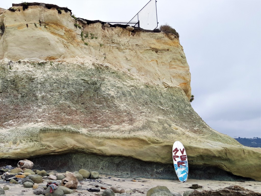
After discovering and sampling the “leopard spots” of “Bright Angel,” it became apparent that Perseverance’s journey of discovery in this region was not yet finished. Approximately 20 sols (Martian days) after driving south across Neretva Vallis from Bright Angel, the rover discovered the enigmatic and unique red rocks of “Serpentine Rapids.”

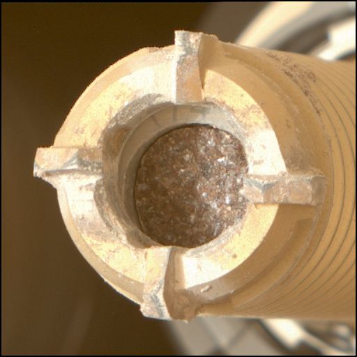
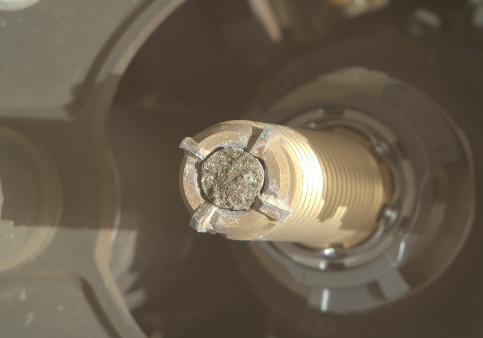
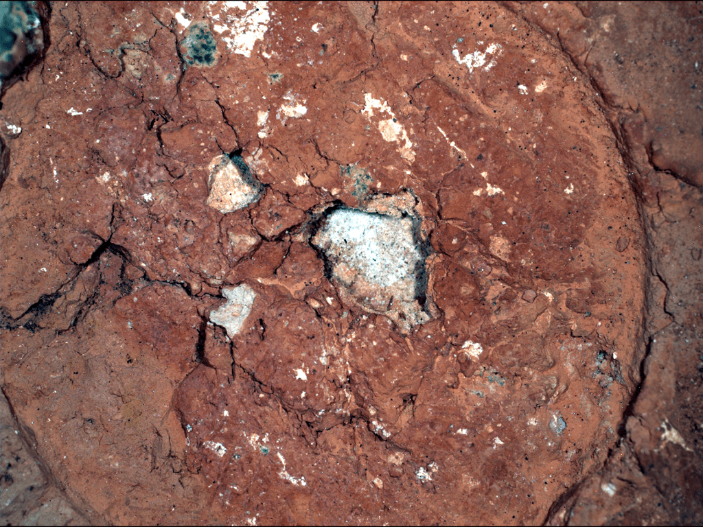
At Serpentine Rapids, Perseverance used its abrading bit to create an abrasion patch in a red rock outcrop named “Wallace Butte.” The 5-cm diameter abrasion patch revealed a striking array of white, black, and green colors within the rock. One of the biggest surprises for the rover team was the presence of the drab-green-colored spots within the abrasion patch, which are composed of dark-toned cores with fuzzy, light green rims.

On Earth, red rocks — sometimes called “red beds” — generally get their color from oxidized iron (Fe3+), which is the same form of iron that makes our blood red, or the rusty red color of metal left outside. Green spots like those observed in the Wallace Butte abrasion are common in ancient “red beds” on Earth and form when liquid water percolates through the sediment before it hardens to rock, kicking off a chemical reaction that transforms oxidized iron to its reduced (Fe2+) form, resulting in a greenish hue. On Earth, microbes are sometimes involved in this iron reduction reaction. However, green spots can also result from decaying organic matter that creates localized reducing conditions. Interactions between sulfur and iron can also create iron-reducing conditions without the involvement of microbial life.

Unfortunately, there was not enough room to safely place the rover arm containing the SHERLOC and PIXL instruments directly atop one of the green spots within the abrasion patch, so their composition remains a mystery. However, the team is always on the lookout for similar interesting and unexpected features in the rocks.

The science and engineering teams are now dealing with incredibly steep terrain as Perseverance ascends the Jezero Crater rim. In the meantime, the Science Team is hanging on to the edge of their seats with excitement and wonder as Perseverance makes the steep climb out of the crater it has called home for the past two years. There is no shortage of wonder and excitement across the team as we contemplate what secrets the ancient rocks of the Jezero Crater rim may hold.

Comet Geyser: Perseverance’s 21st Rock Core

Mars 2020 Perseverance Rover Blog Post: Apr 16, 2024

https://science.nasa.gov/blog/comet-geyser-perseverances-21st-rock-core/

The partially illuminated core is visible in this image of Perseverance’s coring bit. The diameter of the core is 1.3 cm.

Mastcam-Z image (Sol 1088, zcam05068) of the Comet Geyser core. The partially illuminated core is visible in this image of Perseverance’s coring bit. The diameter of the core is 1.3 cm.

NASA/JPL-Caltech/ASU

Written by Adrian Broz, Postdoctoral Scientist at Purdue University/University of Oregon

After investigating the high-standing bedrock at the Bunsen Peak workspace deep within the Margin Unit, the unique nature and composition of this rock was deemed worthy for collection of Perseverance’s 21st rock core sample, Comet Geyser!

Bunsen Peak is named after a prominent peak in Yellowstone National Park, Wyoming, USA, and the namesake for Comet Geyser is the silica-sintered cone geyser also in Yellowstone National Park.

Although this rock’s origin remains under investigation and the rover team continues to explore different hypotheses, this core is particularly exciting because it appears to be composed primarily of two minerals: carbonate and silica. Carbonate and silica are both excellent minerals for preserving biosignatures (ancient signs of life). These minerals also have the potential to record the environmental conditions in which they formed, making them important minerals for understanding the habitability of Jezero crater billions of years ago.

The presence of carbonate within the Comet Geyser sample suggests that water, carbon dioxide, and chemical elements derived from rocks or sediments in and around ancient Jezero crater once reacted here to form carbonate. Carbonate minerals from Earth’s rock record are often used to reconstruct ancient climate–including conditions like temperature, precipitation, and aridity–and the history of life. Similarly, silica phases form when water interacts with rocks or sediments. The composition and crystallinity of silica can reveal the extent of the interaction with water, such as the intensity or duration of weathering and the pressure/temperature conditions during formation.

 On Earth, biosignatures can be preserved in carbonate and silica for millions of years, or even billions of years in the case of silica. Some of the oldest evidence we have of life on Earth is from rocks that contain fragments of microbial cells that were “permineralized” by silica, a fossilization process that entombs the residues of ancient life and protects them from degradation. Thus, rocks containing these materials are considered among the highest priority samples for investigating whether Jezero crater was once host to microbial life. Perseverance’s 21st core sample at Bunsen Peak represents a significant milestone towards collection of a scientifically diverse set of samples for eventual return to Earth as part of the Mars Sample Return mission.

With rock core #21 now onboard, Perseverance presses forward towards its next strategic objective of investigating a location called Bright Angel, which is a light-toned outcrop exposed in the ancient channel wall of Neretva Vallis. Challenges may arise on this journey, as the terrain ahead is littered with sharp boulders and sand that are proving difficult for the rover’s auto-navigation system. The mission’s rover planners are working hard to manually navigate this tricky terrain. In the meantime, the science team is eagerly anticipating the secrets the rocks of Bright Angel may hold!

Mars 2020 Perseverance Blog Post: Bright rocks on the horizon! Long distance imaging of the Jezero Crater Rim

https://mars.nasa.gov/mars2020/mission/status/511/bright-rocks-on-the-horizon-an-exciting-glimpse-of-uncharted-territory/

BLOG | February 01, 2024

Bright Rocks on the Horizon: An Exciting Glimpse of Uncharted Territory
Written by Adrian Broz, Postdoctoral Scientist at Purdue University/University of Oregon

Mastcam-Z image showing bright, light-toned outcrops near the Jezero Crater Rim (upper center) approximately 4 km away, with darker toned boulders in foreground (center).

Mars Perseverance Sol 1039 – Left Mastcam-Z Camera: Mastcam-Z image (Sol 1039, zcam03849) showing bright, light-toned outcrops near the Jezero Crater Rim (upper center) approximately 4 km away, with darker toned boulders in foreground (center). Credits: NASA/JPL-Caltech/ASU. Download image ›

Perseverance is deep within the ongoing Margin Unit campaign, where orbital signatures of carbonate minerals appear strongest. After collection of a drilled rock core from the Margin Unit, followed by 20 Sols (Martian days) parked at our current workspace, Perseverance had ample time to explore the rocks adjacent to the rover and perform long distance multispectral imaging of the Jezero Crater Rim with the Mastcam-Z instrument.

The science team has been working around the clock to understand the origin, composition and alteration history of massive, dark-toned rocks in the Margin Unit. Challenges abound, however, as many of these exposed rocks are covered in a thick, crusty dust layer that partially obscures our ability to understand their true composition.

Perseverance is approaching a small, ~50-m-wide impact crater that has created a natural cross-section of rock layers of the Margin unit, potentially providing new views of deeper bedrock. The team is eagerly awaiting images of the interior of this small crater, which could reveal information about the emplacement of the upper Margin Unit.

In the upcoming rover traverse, Perseverance will climb up onto the Jezero Crater Rim after a stop in Neretva Vallis, a deep channel that appears to have once fed water and sediments into Jezero Crater. The first long-distance glimpse of this uncharted territory did not disappoint!

Based on orbital satellite images, rock layers near the Jezero Crater Rim are thought to be among the oldest rocks that could be explored by a rover on Mars. Therefore, the light-toned rock layers pictured here could represent much older strata than has yet been explored by Perseverance – possibly dating back to the Noachian (approximately 3.7 – 4.1 billion years ago). Exploration of these terrains could provide unprecedented insight into the climate and environmental habitability during earlier and possibly wetter periods in Mars’ history.

In anticipation of Perseverance’s upcoming Crater Rim traverse, the team has been working to use orbital images to create a high-resolution map of geological features throughout the Crater Rim, including the light-toned bedrock in the image. These geological maps will be used to plan the upcoming traverse of the Crater Rim and for outlining the highest-priority rock units for collection of drilled rock core samples that could one day be returned to Earth.

Mars 2020 Perseverance Blog Post: Sampling carbonate-rich bedrock at the Margin unit, Jezero Crater, Mars

New blog post live! : https://mars.nasa.gov/mars2020/mission/status/490/a-tale-of-turquoise-bay-sampling-unique-bedrock-at-the-margin-unit/

BLOG | October 23, 2023

A Tale of Turquoise Bay: Sampling Unique Bedrock at the Margin Unit
Written by Adrian Broz, Postdoctoral Scientist, Purdue University/University of Oregon

NASA's Mars Perseverance rover acquired this image using its Right Mastcam-Z camera. Mastcam-Z is a pair of cameras located high on the rover's mast.

Mars Perseverance Sol 942 – Right Mastcam-Z Camera: Mastcam-Z image (Sol 942, zcam05068) of drilled rock core collected from Turquoise Bay bedrock at the Marginal Unit, Jezero Crater, Mars. Credits: NASA/JPL-Caltech/ASU. Download image ›

The Mars 2020 team has been exploring a new area of the Margin Unit at Jezero Crater, where distinct carbonate signatures have been observed from orbit. Importantly, carbonates that form in rocks can store a record of the climate during formation, and they can also preserve biosignatures (residues of ancient life).

Perseverance is on its way to a particularly interesting region of the Margin Unit, known as Jurabi Point, where three rock units appear to intersect. These different rock types are known as the Upper Fan sedimentary rocks, the Boulder-rich Unit, and, with its unique carbonate signature, the Margin Unit. Interestingly, the signatures of carbonate minerals that are seen from orbit appear to be strongest near our current location. A rock core sample at this location may contain carbonate minerals and therefore serves as a representative sample for the Margin Unit campaign.

As part of the ongoing investigation of the rocks in the area, Perseverance recently performed an abrasion patch on a large slab of bedrock at Turquoise Bay. The abrasion patch here ground through a thick dust layer and revealed interesting and unique textures and features in the fresh bedrock! The Mars 2020 team has been carefully analyzing these rocks and has been comparing and contrasting the features here with previous rock cores that have been collected.

The bedrock at Turquoise Bay was deemed unique and worthy for collection of a drilled core sample and a rock core was successfully collected by Perseverance. Mastcam-Z images of the core confirmed that it was successfully acquired, and the core is now in the process of being sealed for eventual return to Earth.

Over the next few Sols, Perseverance will conduct remote sensing science on the drill core tailings since they can provide insight into the potential composition of rock inside the drill core. After sampling wraps up, we will complete the drive to Jurabi Point where Perseverance will use remote and proximity science to investigate rocks at higher levels in the Margin Unit.

Mars Sample Return and the Mars 2020 Perseverance Rover

Our work at “Hogwallow Flats”, Jezero Crater, Mars was just mentioned in this Nature article. Check it out!

We collected three rock cores from the “Hogwallow Flats” area for return to Earth (pictures below). This area contains sedimentary rocks that were most likely altered by interactions with liquid water, which suggests habitable environments when they formed. The rocks we sampled contain significant amounts of clay minerals and sulfates, both which are materials associated with the preservation of biosignatures. They also represent the finest-grained rock samples collected by the mission so far. If there was ever life in Jezero Crater, its leftover residues (biosignatures) may be present in these samples. We will be working hard to get these samples back to Earth by the early 2030’s!

https://www.nature.com/articles/d41586-023-00927-z

Geology and surfing: An Eocene (50-55 Ma) tropical greenhouse climate recorded in nonmarine rocks of San Diego, CA, USA

2024 Update: This work was recently published in Nature Scientific Reports. Check it out!

A few years ago, we were surfing at Cardiff-by-the-Sea over the magical reefs that lend the area incredible surfing conditions and shapely wave formation. Something out of the ordinary caught my eye – paleosols sandwiched in the beach cliff! At the south end of San Elijo State Beach, near the rivermouth – there was a perfectly preserved sequence of three deeply weathered paleosols (ancient, buried soils). Even more exciting was the realization that Cardiff Reef itself (the shore platform extending out to sea) was part of the paleosol sequence! Who could have imagined – surfing atop an ancient soil!

A sequence of Eocene (~50 Ma) deeply weathered paleosols (green and red layers) in the beach cliff at the south end of San Elijo State Beach, Cardiff, CA.
Cardiff Reef, San Elijo State Beach, Cardiff, CA (Getty images)

After a short review of the geological history of the region, it was apparent that we were dealing with REALLY OLD soils – between 50 and 55 million years old! Even more exciting was that these soils had the telltale signs of intense, tropical weathering: the profiles were dominated by kaolinite and were very thick, approximately 3 meters deep. So, our surfing/geology side project began. We returned in January of 2021 to describe and sample the ancient soils at three locations where they are naturally exposed in the beach cliffs: San Elijo, Black’s Beach, and Torrey Pines. The objective of this work was to constrain the paleoclimate conditions (mean annual precipitation, mean annual temperature) during soil formation. Critically, this period in geological history (known as the Paleocene-Eocene “thermal maximum” was the last time that atmospheric CO2 was as high as is projected for the year 2100 (between ~1000 and 2000 ppmv CO2, we are currently at ~420 ppmv). Therefore, studying soils of the past can help to constrain how climate and ecosystems will respond to modern global warming, and provide unprecedented insight into the climate evolution of present day southern California during the Paleocene-Eocene thermal maximum.

The lowermost paleosol profile (mottled green-red due to burial gleization) composes the shore platform and goes out to sea to make the incredible surfing spot known to local surfers as “Cardiff Reef”. Massive and extensive sand-filled polygonal mudcracks are diagnostic of a Vertisol (high shrink-swell soil).

Abstract: Nonmarine rocks in sea cliffs of southern California store a detailed record of weathering under tropical conditions millions of years ago, where today the climate is much drier and cooler. This work examines early Eocene (~ 50–55 million-year-old) deeply weathered paleosols (ancient, buried soils) exposed in marine terraces of northern San Diego County, California, and uses their geochemistry and mineralogy to reconstruct climate and weathering intensity during early Eocene greenhouse climates. These Eocene warm spikes have been modeled as prequels for ongoing anthropogenic global warming driven by a spike in atmospheric CO2. Paleocene-Eocene thermal maximum (PETM, ~ 55 Ma) kaolinitic paleosols developed in volcaniclastic conglomerates are evidence of intense weathering (CIA > 98) under warm and wet conditions (mean annual temperature [MAT] of ~ 17 °C  ± 4.4 °C and mean annual precipitation [MAP] of ~ 1500 ± 299 mm). Geologically younger Early Eocene climatic optimum (EECO, 50 Ma) high shrink-swell (Vertisol) paleosols developed in coarse sandstones are also intensely weathered (CIA > 80) with MAT estimates of ~ 20 °C ± 4.4 °C but have lower estimated MAP (~ 1100 ± 299 mm), suggesting a less humid climate for the EECO greenhouse spike than for the earlier PETM greenhouse spike.

Erosional remnant of a kaolinitic Oxisol paleosol (55 Ma) in the Mt. Soledad Formation, Black’s Beach, La Jolla, CA (directly below the “Indian Trail” at UCSD).

Did the Curiosity rover just encounter an ancient soil profile on Mars?

The Mars Science Laboratory onboard Curiosity rover has been traversing up the slopes of Mt. Sharp since landing on Mars in 2012. In late 2021, the rover entered a new region of Mt. Sharp known as the “Sulfate-bearing unit” because of the widespread orbital detections of sulfate minerals from orbit (Figure 1).

The sulfate-bearing unit has spectral signatures of hydrated sulfates and is estimated to be ~700 meters thick in the northwest portion of Mt. Sharp (Rapin et al., 2021). Large-scale (5-10 meter) trough cross beds in the lowermost unit are consistent with an eolian sequence. Stratigraphically above the basal unit, a possible deflationary surface (the “Marker bed”) is topped by what appears to be a fluvial depositional system, which is consistent with an alternating wet-dry climate regime for this unit, rather than a monotonic shift to arid conditions. Since alternating wet-dry conditions in terrestrial environments can lead to regional-scale subaerial weathering of sediments, it is possible that individual weathering profiles could have formed in the sulfate-bearing unit during periods of subaerial exposure.

Figure 1. Putative paleosol within the basal sulfate-bearing unit (LSu) at Gale crater (a-b) inferred from decimeter-sized concretions (c), dark-toned nodular beds (d) and sulfate-enriched polygonal mudcracks (e-f), adapted from Rapin et al., 2022

The identification of what appears to be the first paleosol at Gale Crater (Rapin et al., 2022) (Figure 1) is consistent with the alternating wet-dry-hypothesis for the origin of the sulfate-bearing unit. Polygonal mudcracks and sulfate nodules are common features of sulfate-rich lake margin soils and are also common in more developed smectitic (montmorillonite/nontronite-rich), shrink-swell soils, classified as Vertisols in US taxonomy. These observations now present a unique opportunity for comparisons with terrestrial weathering profiles containing similar features such as mudcracks and nodular sulfate minerals which together can provide a reference frame for evaluating a subaerial weathering hypothesis for the origin of altered sediments at this location.

We have submitted a proposal the the NASA SSW program to fund a terrestrial analog study to evaluate a pedogenic origin for features observed in the sulfate-bearing unit by examining sulfate-rich paleosols with rover-like instruments (Figure 2). Wish us luck!

Figure 2. Desert roses (A-D) and crystals (E-F) in hand specimens of terrestrial paleosols, and G-H, comparisons with concretions at Gale crater: A, clay pseudomorph of gypsum desert rose from By horizon of Thamberalg pedotype in Ediacaran (599 Ma) Ranford Formation, Donkey Creek, Western Australia; B, silica pseudomorphs of gypsum desert roses in By horizon of Muru pedotype from Ediacaran (547 Ma) Ediacara Member in Brachina Gorge, South Australia; C, barite desert roses from Oligocene (20 Ma) Rockenberg Formation near Rockenberg, Germany; D, barite desert roses from By horizon of pedotype from Early Permian (270 Ma) Garber Sandstone near Cimarron City, Oklahoma; E, silica pseudomorphs of mirabilite in A horizon of Viku pedotype from Cryogenian (640 Ma) Reynella Siltstone Member Hallett Cove, South Australia; F, ripidolite pseudomorphs of kieserite in By horizon of Isi pedotype from Archean (3700 Ma) Isua Greenstone near Isukasia, Greenland; G, Mastcam image (Sol 1277) showing concretions from the Murray Formation; H, Mastcam image (Sol 3396) showing concretions and evaporite pseudomorphs from the clay-sulfate transition. Terrestrial specimens in Condon Collection of Museum of Natural and Cultural History, University of Oregon are (a), R4185 (b), F6345 (d), field photographs (c, e-f).

Rapin, W., Dromart, G., Rubin, D., Deit, L. Le, Mangold, N., Edgar, L. A., et al. (2021). Alternating wet and dry depositional environments recorded in the stratigraphy of Mount Sharp at Gale crater , Mars. Geology, 49(7), 842–846.

Rapin, W., Sheppard, R., Dromart, G., Schieber, J., Kah, L., Rubin, D., et al. (2022). The Curiosity rover is exploring a key sulfate-bearing orbital facies. Lunar and Planetary Science Conference, 2473.

Introducing the Mars Organic Molecule Analyzer (MOMA)

MOMA is an instrument designed to detect organic molecules on Mars and will fly onboard the upcoming ExoMars 2022 Rosalind Franklin rover, due to land in June 2023 at the ~4 billion year old Oxia Planum region. Here, what appear to be ancient weathering profiles have been detected from orbital remote sensing, and the rover may encounter these rocks during its primary mission. Exciting science to come!

(Rover) eyes on the prize

Before research lockdown due to COVID-19:

Assisting with the deployment of the Mastcam-Z engineered prototype, a multispectral, high resolution 3D camera which is now flying on Mars 2020 Perseverance Rover. The prototype was designed and built by Megan Barrington and Alex Hayes, Cornell University. It was an exciting and humbling opportunity to work with members of the Mastcam-Z team during the deployment of the prototype at our Mars-analog site (near the Painted Hills, Eastern Oregon).

The Perseverance rover will seek signs of ancient life and collect rock and soil samples for possible return to Earth.

The goal of this research was to collect hyperspectral images of soil clays and other hydrated phases for use during the Mars 2020 Perseverance Rover mission.

Mastcam-Z. Photo: Jim Bell
Photo: NASA/JPL-Caltech